
In Part 1, we saw the definitions of Nations and Nationalism and how they evolved across centuries. In this Part, we shall see how these theories of Nations and Nationalism fail to make sense while trying to define and understand Bharatavarsha. When someone claims that India was never a Nation, it only betrays a poor understanding of the nature of India’s Nationhood.
The Notion of Bharatavarsha – A Sacred Geography and a Cultural Civilization
India can be described as a diverse but united, cultural, civilizational space but not as a political unit in the western sense. The earliest reference (326 BCE) to a quadrilateral shaped united land (the Indus River as the western boundary, the Himalayas and the Hindu Kush Mountains in the north, and the seas skirting the two sides) is in the Greek descriptions during Alexander’s times. As the latest book by Meenakshi Jain (The Hindus of Hindustan) informs, Alexander’s historians mentioned India measuring sixteen thousand stadia (1,838 miles) from the Indus to the mouth of Ganga. From the mouth of Ganga, it was another 16,000 stadia along the eastern coast to the southern tip of India; 19,000 stadia (2,183 miles) across the western coast from the southernmost tip to the mouth of Indus; and 1,300 stadia (1,496 miles) defining the western border of India along the course of the Indus River. Jain quotes Cunningham (1871) who says, ‘The close agreement of these dimensions… with the actual size of the country is very remarkable, and shows that the Indians, even at that early date in their history, had a very accurate knowledge of the form and extent of their native land’.
As Michel Danino writes that it were in fact the Ramayan and the Mahabharat which were the major tools for integration rather than the Vedas and the Upanishads. The references to the great Epics are all over the country and even in places like Indonesia, where local traditions always link in some way to the two great Epics. In a mutually augmenting phenomenon, people from different areas of the country identify their place or lineage with incidents, places and peoples in the Puranas or Itihaasas.
Sarayu, Ayodhya, the Sona River, Vaishali, Mithila, Kosala, Chitrakoot, Mandakini, Godavari, Lanka, Dandaka forest, Pampa, Vindhya Mountains, Narmada, Suraashtra and many such references in the Ramayan allude to the idea of a unified Bharatavarsha where there was no restriction from traveling across these regions. Fluctuating Kingdom boundaries and political divisions hardly mattered when it came to movement of people and the royalty.
Though some scholars maintain that the Ramayan geography restricts to the north of the Vindhyas, the Mahabharat, a massive text of 1,00,000 verses, is unambiguous in its descriptions and travel narratives covering Bharatavarsha extensively – its rivers, mountains, lakes, forests and Kingdoms. Irrespective of the dating of the Mahabharata (950 BCE, 1792 BCE, 3067 BCE, or 5556 BCE), Bharatavarsha as a unified entity in this text can be traced back to much before the time of the Buddha (563 BCE).
The Bhishma Parva of the Mahabharat starts with the description about the cities, countries, rivers, mountains and forests of the warriors gathered for the Kurukshetra war. Twenty-four verses of Bhishma Parva name one hundred and fifty rivers including the Ganga, Yamuna, Saraswati, Indus, Godavari, Narmada, Krishna, Rushikulya (Orissa) and Kaveri across the Indian sub-Continent. Thirty-two verses mention 220 Kingdoms across Bharatavarsha. Of these 195 are Kshatriya provinces. Kuru-Panchala, Kalinga, Vidarbha, Surastra, Kasmira, Magadha, Dravida, Keralah, Andhras, Pahlavas, Vindhya and such names resonate well with the present names and regions.
Jijith Nadumuri Ravi has made an incredible analysis of all proper nouns (places, pilgrim centers, Kingdoms, rivers, lakes, mountains, forests, or seas) in the Mahabharat. The analysis and detailed maps of 100 places, 30 forests, 30 lakes, 80 mountain ranges, 60 geographical regions, 300 pilgrim places and 80 Kingdoms offer a strong argument for a culturally, spiritually and geographically united people of Bharatavarsha. Important travel narratives reveal the networks and an inter-relation of different parts of Bharatavarsha. Balarama’s travels, the journeys of the Pandavas in the forests or their final journey, and Krishna’s travel to Magadha are a few examples.
Similarly, Chapter 19, Canto 5 of the Bhagawat Purana clearly describes the glories of Bharatavarsha. Verses describe the Malaya Mountains (Southern part of Western Ghats), Sahya Mountains, Risaba, Kutaka, Kollaka, Sahya, Devagiri, Rsyamuka, Sri-saila, Venkata, Mahendra, Varidhara, Vindhya, and so on. Among the rivers, Brahmaputra and Sona get a prominent place. Other rivers mentioned are the Kaveri, Tapi, Yamuna, Saraswati, Gomati, Sarayu, Satadru, Asikni (Punjab), Narmada, Mahanadi, Rsikulya (Orissa), Tungabhadra, Mandakini, Godavari – important rivers which purify the inhabitants of Bharatavarsha. The Vishnu Purana describes Bharata as the ‘land north of the ocean and south of the snowy mountains or the Himalayas’.
Radhakumud Mookerji in his classic, ‘The Fundamental Unity of India’ and in recent times, Sankrant Sanu (Why India is a Nation), elegantly sum up the evidence for the geographical, cultural and civilizational unity of the people. As Sanu says, for thousands of years, Indians throughout the land wake up in the morning and sing a hymn from the Brihannaradiya Purana celebrating the Holy rivers of Ganga, Yamuna, Narmada, Godavari, Sindhu, Saraswati and Kaveri as part of their daily ritual.
Michel Danino says, ‘The Jyotirlingas, the Shakti Mahapithas and the Upapithas spread over India, Nepal, Bangladesh and Pakistan became the defining point to draw the boundaries of the country. The cultural integration began in the Harappan times and accelerated during the Gangetic civilization phase in about 700 BC. It was an organic process and not controlled by any central authority’. The consciously created networks include the Char Dhams at the four ‘corners’ of the land; the twelve Jyotirlingas; the Kumbha mela sites; the 108 Divya Desam shrines to Vishnu; and numerous regional networks. In the Tantric schools, the legend of Shakti describes the body pieces cut by Vishnu landing at the 51 sites of Shakti Peetham temples – from Neelayadakshi Kovil in Tamil Nadu to Vaishno Devi in Jammu, and from Pavagadh in Gujarat to Kamakshi Temple in Assam.
Adi Shankara’s extensive travels covered the length and breadth of country. He established the four Mathas in the four corners of the country which are even today important places of pilgrimage : Dwarka (East), Puri (West), Badrinath (North) and Sringeri (South). Bhakti movement Saints starting from the 6th Century also reflect the cultural and spiritual unity of the people. These Saints included the Alvars and the Nayanars (Tamil, 7th to 10th Century), Kamban (Tamil, 11th Century), Basava (Kannada, 12th Century), Chaitanya Mahaprabhu (Bengali, 15th Century), Annamayya (Telugu, 15th Century), Surdas (Braj, 16th Century), Mirabai (Rajasthan, 16th Century), Tulsidas (Avadhi, 16th Century), Nanak (Punjabi, 16th Century), Bhakta Ramadasu (Telugu, 17th Century) and Tukaram (Marathi, 17th Century), amongst the many.
They wove a garland across the land speaking of our common truths, our common cultural heritage and our ancient stories in local languages. These Saint-poets evolved an immense body of pan-Indian worship around the triad of Vishnu, Shiva and Shakti in their various forms – Ram, Krishna, Sri Venkateshwara, Sri Dakshinamurti, Durga Mata or Kali.
Never A Political Unity ?
Contrary to colonial narratives, there were large pan-India political unifications. The Maurya Dynasty, founded by Chandragupta Maurya, dominated the Indian sub-Continent between 322 and 185 BCE with the capital at Pataliputra (Patna). Under Ashoka, it extended from the present-day Assam to eastern Afghanistan, an area of five million square kilometres. Kautilya’s exhaustive Arthashastra (2nd Century BCE) does not mention the imposition of a single language or traditional practice across the State.
The Kushana Dynasty (1st Century CE to 4th Century CE), founded by the Buddhist king Kanishka, was a huge empire encompassing Afghanistan and northern India reaching Varanasi. Sanskrit, Greek and Bactrian were the official languages and people practised Buddhism, Hinduism and Zoroastrianism. After the fragmentation of the Kushana Kingdom, the Guptas (3rd Century CE to 543 CE) covered much of the Indian sub-Continent.
In the South, the Satavahanas (2nd Century BCE to 3rd Century CE), the Chalukyas (543 CE to 753 CE) and the successive Sangama, Saluva, Tuluva and Aravidu dynasties of the Vijayanagara Kingdom (1336 CE to 1646 CE) ruled across major areas of present-day central States – Maharashtra, MP and extending up to Gujarat. Multiple languages were spoken and multiple faiths followed, and that was the norm. Arts, architecture, public administration, and trade flowered maximally in the Vijayanagara Kingdom, its most popular king being Krishnadevaraya. The popular languages were Kannada and Telugu with Sanskrit as the official language.
In the concluding Part, read about the spiritual perspective of Sri Aurobindo, and the cunningness of the British in dividing us using the Abrahamic mould.
– Dr Pingali Gopal (Excerpts from an Article under the same Title, Courtesy : IndiaFacts.org, 21.4.2023)
(Dr Gopal is a Paediatric and Neonatal Surgeon.)
|
 Smoking causing an extreme effect on the Kundalini-chakras of a seeker
 FCRA, Foreign Funds, Domestic Security and India-US Friction : A Timeline of Recent Developments
 Tired of the hard-line ideology of Islam, embraces Sanatan Dharma along with his wife and children !
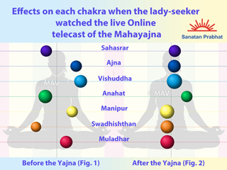 Six Kundalini-chakras of a lady-seeker becoming conducive to imbibing Chaitanya after watching the Shri Rajamatangi Mahayajna Online
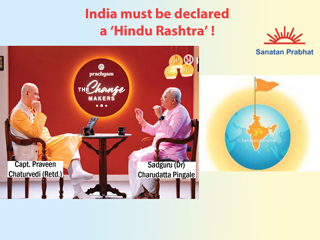
 Only Dharma can unite Hindus !
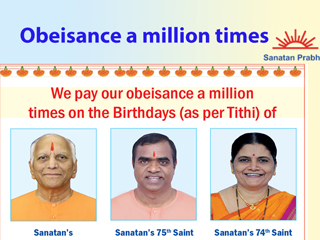 We pay our obeisance a million times on the Birthdays (as per Tithi) of …