The Central Government’s statement in the Parliament !

New Delhi – Satellite pictures of the place between India and Sri Lanka which is accepted as the site of RamSetu have been taken. “Yes, to some extent, through space technology we have been able to discover pieces and islands, some kind of limestone shoals, which of course can’t be accurately said to be remnants or parts of a bridge,” minister of state for space Jitendra Singh told the Rajya Sabha.
VIDEO: #RajyaSabha discussion on scientific evidence through Space technology of ancient Indian structures. pic.twitter.com/moxaOW8MU0
— Dr Jitendra Singh (@DrJitendraSingh) December 22, 2022
Jitendra Singh said this in response to BJP MP Karthikeya Sharma’s question about whether any attempt is being made to conduct a scientific study of India’s history. “I am glad to share with him that the department of space is actually engaged in this… As far as the question that was asked by him here concerning the Ramsetu, we have certain limitations in discovering that because the history dates back more than 18,000 years, and if you go by history, that bridge was about 56km long,” Singh added
Congress had denied in the Supreme Court that Shriram built the Ramsetu !
In 2005 the then Congress Government announced a large canal project called the Setusamudram. There was talk that in some places the Ramsetu was dug and so destroyed. So that ships could sail through it. The project also included the plan of making Rameshwaram a big port. This would create a direct passage between the Arabian Sea and the Bay of Bengal. It was projected that this would give a profit of Rs 50,000 crores. When there was opposition to this project the Government claimed in the Court that ‘Shriram was imaginary so he did not build the Ramsetu’. When there was nationwide opposition to this the Government took back that claim and later cancelled the project as well. Also, the scientists felt that the Tectonic plates below the bridge if weakened could cause great natural calamities. The environmentalists said this was the location of 36 thousand of endangered species. Destruction of this bridge will cause the destruction of the habitat of endangered species and affect the Monsoon cycle.
Information about Ramsetu
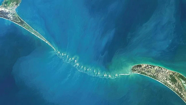
The land between India’s Rameshwaram and Sri Lanka’s Munnar is a chain of limestone shoals. In India, it is called the Ramsetu and worldwide it is known as Adam’s Bridge which is a 48 km long land bridge between India and Sri Lanka. This bridge separates Munnar Bay and Palk Straits. Here the sea is very shallow. This makes the movement of large ships difficult. It was reportedly passable by foot until the 15th century when storms destroyed the integrity of the bridge as the sea deepened and the bridge sank into the sea. In 1993 the US space research organisation NASA published pictures of the Ramsetu taken from the satellite. In which it was described as ‘man-made’.
Modi Government says, ‘there is no proof of Ramsetu !’ – CongressCongress Leader Pawan Khera criticised the Central Government’s statement about the Ramsetu. Khera said in his Tweet, all you Bhakts, Devotees, hear carefully and open your eyes and see.
Modi Government is saying in the Parliament, that there is no proof of there being a Ramsetu. |
 Statement by Samajwadi Party leaders expressing anger over a poster displayed in Mathura (UP) reading, “Babar in the heart, Ram on the lips”
 Mountains of garbage pile up on Mumbai’s Juhu Beach !
 Anti-Terrorism Squad conducts raids at more than 23 locations in Pune and Pimpri-Chinchwad !
 Five terrorists arrested in Gujarat ahead of Bhagwan Jagannath’s Rath Yatra
 A Jharkhand gram panchayat fines Rs 1 lakh and releases accused who sexually assaulted a 3-year-old
 One arrested in the Badrinath Dham theft case