 Google Maps shows Jammu & Kashmir’s outline as a dotted line acknowledging ‘dispute’ when it is seen from outside India as the search engine redraws the world’s borders based on where the user is viewing them from.
When J&K is searched from India on Google Maps, it displays a solid grey outline bordering the region and shows it as part of the country. However, when searched from a location outside of India, such as in Europe, Outlook found the lines appeared dotted. Google Maps said – disputed boundaries are displayed as a dashed grey line. The places involved don’t agree on a boundary.
According to a report in a major American Daily – Washington Post – ‘The borders on Google’s online maps display J&K as fully under Indian control. Elsewhere, users see the region’s snaking outlines as a dotted line, acknowledging the dispute. From Pakistan, J&K appears disputed, while from India, it appears as a part of India, the Post report said.
Responding to the Post report, a Google official said – Google has a consistent and global policy to depict disputed regions and features fairly, showing claims made by the disputed or claiming Nations on its global domain. This does not endorse or affirm the position taken by any side. Products that have been localised to the local domain such as maps.google.co.in, depicts that country’s position as per the mandate of the local laws. We’re committed to providing our users with the richest, most up-to-date and accurate maps possible. We do border updates based on data from our providers as new or more accurate data becomes available from authoritative sources or geopolitical conditions change.
 Great scientist Aryabhata insulted in an ‘Amazon India’ advertisement!
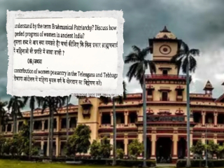 Controversy at BHU over question on ‘Brahmanical patriarchy’
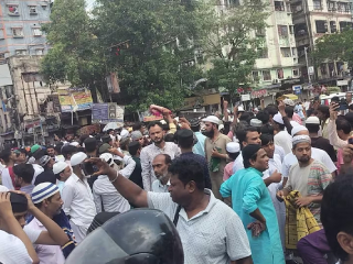 In Kolkata, Muslims Avoided Offering Namaz on the streets Due to the Strict Stand Taken by the Police!
 I am not against people visiting temples, but against discrimination: Udhayanidhi Stalin
 Pakistani-made fan found installed in a madarasa in Kushinagar, UP
 Maharashtra ATS conducts raids across the State